Phase 1 · Complete
Environmental baseline
25 years of data across five fault zones. Pre-registered and filed.
Phase 2 · In progress
A harder benchmark
One region, measured against the forecasting models seismologists already use.
Every result published
Five results filed
Null and exploratory alike, on OSF and GitHub. See results →
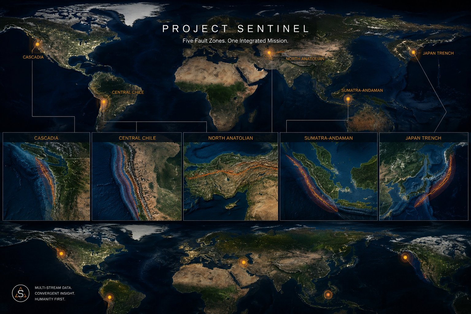
Five fault zones · Cascadia · Japan Trench · North Anatolian · Central Chile · Sumatra-Andaman
The long-term goal: a probabilistic platform across all six FEMA hazard categories, built to improve risk awareness and help protect lives.
Sentinel's work to date has been pseudo-prospective: chronological walk-forward validation on historical data, with the model never permitted to see the future of its test window. That structure stays. What changes is the baseline it gets compared against.
| Question | Initial approach | Next phase |
|---|
| Question asked | Does this signal separate pre-event from non-event windows better than chance? | Does this signal improve a forecast a seismologist would already accept? |
| Baseline | A fixed statistical threshold (a seismic-only feature model) | ETAS and smoothed seismicity |
| Metric | AUROC, ranking only | Information gain, calibrated probability |
| Model output | A score over a window | A probability for each grid cell and time bin |
Earthquakes cluster in space and time, so a feature that merely tracks an active period in an active place can look predictive while adding nothing a standard forecasting model did not already know. A benchmark built from ETAS and smoothed seismicity already contains everything the field gets for free. Raising the bar to this standard is what lets a genuine signal be told apart from a pattern the field already expected.
Two initial analyses are complete with writeups in progress: A dedicated Phase 2 null-results paper covering the pre-registered hypotheses and walk-forward evaluation, centered on a fold that returned an initial AUROC of 0.900 before failing to sustain under the pre-registered protocol and being correctly scored null. And a separate methods paper on the superposed-epoch post-event finding, following a novelty search to confirm it hasn't already been described elsewhere. Both will be filed to OSF and GitHub alongside the results already on the For Researchers page.
The earlier ionospheric analysis relied on the best available global maps at the time. Higher-fidelity, receiver-level TEC data is now accessible, offering a genuine upgrade in measurement quality for this phase.
Madrigal / MIT Haystack
Line-of-sight slant GNSS TEC with pierce points, roughly 30-second cadence, from 6,000+ receivers globally, continuous since 2000. The genuine upgrade over the gridded IONEX maps used in the H3 analysis.
Open · registration required · HDF5
EarthScope / NOTA
1,200+ continuous instruments across 20+ countries: multi-constellation GNSS, borehole strain, seismic, and tilt. Custom high-rate requests available for specific sites and periods.
Free for noncommercial scientific use
NASA CDDIS
High-rate GNSS observation data at 1-second sampling, global coverage, available from 2001 forward.
Open access
Every stream Sentinel touches sits somewhere on a hierarchy from established science to open research hypothesis. Each tier is scored against its own standard of evidence, and none is allowed to borrow credibility from another.
Core Baseline
Seismicity rates · spatial patterns · aftershock statistics
Established forecasting information.
Primary Experimental
GNSS / strain · b-value / catalog features
Physically grounded, with short-term forecasting skill still developing.
Contested Geophysics
TEC · EM · thermal · atmospheric / geochemical
An actively conflicting, confound-heavy literature.
Structured Human Data
Dreams · intuition reports · anomalous cognition inventories
Phenomenology that can be structured, with anomalous information content still unestablished.
High-Uncertainty HAC
Precognition · presentiment · remote viewing
Positive claims that coexist with significant replication failures.
Cross-Domain Convergence
Geophysical + HAC incremental information
Unestablished. This tier is Sentinel's own research hypothesis, stated openly as such.
A measurable stream is not automatically a predictive stream.
The strategy adapts at each phase. Null results redirect the plan; confirmed signals accelerate it.
12026 · complete
Environmental Baseline
Earthquakes only
- Solar/geomagnetic vs. seismic
- 25-year backfill complete
- AUROC evaluation
- Pre-registered null confirmed
22026 · in progress
Single-Region Convergence
Earthquakes only
- One validated region
- 7 data streams
- Benchmarked against ETAS
- GPS + high-fidelity TEC
32027
Convergence Engine
Earthquakes only
- Multi-stream scoring
- Extension to remaining fault zones
- Probabilistic output
- No deterministic prediction
42027–28
Multi-Hazard Expansion
All hazards
- Tsunami ground truth
- Volcanic catalog
- Flood / landslide
- Shared ingestion
52027–28
HAC Integration
Protocol TBD
- Convergence result informs design
- HAC protocol design
- Structured intake
- Prospective only
62028+
Institutional Collaboration
If signal exists
- Academic partnership
- Independent replication
- Grant funding
- Federal agency engagement
7Vision
Operational Prototype
Probabilistic
- Live monitoring
- Bounded risk signals
- Calibrated uncertainty
- Every forecast logged
Earthquakes
USGS ComCat
350K+ events
Phases 1–3 active
Tsunamis
NOAA NGDC
Inherits EQ infra
DART buoys
Volcanoes
Smithsonian GVP
USGS networks
SO₂ satellites
Floods
NOAA gauges
NWS alerts
Atmospheric rivers
Landslides
NASA global catalog
SMAP soil moisture
Precipitation
Avalanches
SNOTEL snowpack
Regional centers
Temp + precip
Long-term vision
A single probabilistic platform covering all six FEMA hazard categories: bounded risk signals, calibrated uncertainty, and every forecast logged before the outcome is known. A tool meant to increase risk awareness, inform decisions, and help protect lives.